Hiking to Bryant Lake and Glacier
Two weeks ago (August 5-8), I hosted an Alaska hiking club in the White Pass, and members from Haines and Anchorage came to explore this incredible area, with Bryant Lake our first major hike.
I’d been worried about the weather ever since we’d started planning this a few months ago, but it was looking great in Whitehorse and even as far south as Tutshi Lake, seen in this photo.

By the time I reached Summit Lake, though, clouds had moved in and a strong wind had kicked up. The first arrival and I added a layer of clothing and went down to the beach for a while anyway.

When I heard the whistle of the WP&YR steam train heading north from the summit, we raced north to the good viewing spot overlooking the Thompson River. I love any train, but this steam locomotive, built for the White Pass and Yukon Route by Baldwin Locomotive Works in 1947, is extra special.

Next, I wanted to make the short but far-from-easy hike up to the canyons on Summit Creek that I’d seen from Summit Creek Hill 3 weeks before. While from a distance this valley looks easy to cross, it’s actually thick, chest-high brush.

Hiking up to cross a ridge that looked like it would take us to the upper canyon, we came to this creek with a bed that was so level it looked almost like paving stones. It’s not the first time I’ve seen such formations, but they’re rare and I have no idea what causes it.

Success. The bottom of the upper canyon on Summit Creek. Well, upper canyon so far – there may be more higher up the creek 🙂
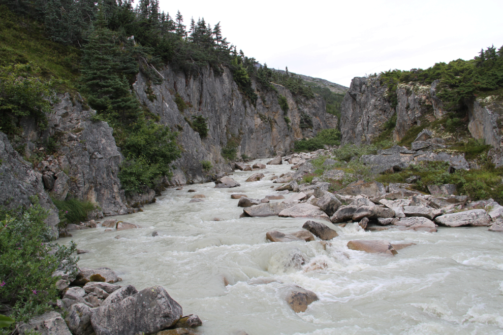
And a few minutes later, the top of the lower canyon. I was hoping that we’d be able to hike into both canyons, but there was no way to do that.

Starting to set up camp beside the South Klondike Highway just south of Summit Creek on Friday evening. The highway is never very busy, but gets very quiet once the cruise ship tours quit for the day, and is closed from midnight to 08:00 between the US and Canadian border posts (this spot is about halfway between them.

On Saturday morning, a thick, cold fog blanketed the White Pass, but I went for a drive to see if there were any clearings where we could hike. No luck to the south, but to the north, the Bryant Lake valley was all clear. As I got back to camp, this hoary marmot (of the subspecies Marmota caligata caligata, I believe) was sitting on the guardrail 100 yards from the motorhome, and hung around for a longer photo session.

Because of the weather, we didn’t get to the Bryant Lake trailhead until just after 10:30. It was quite incredible to be able to quickly hike out of the cold fog!

The height of Bryant Lake was raised with an earthen dam 40-odd years ago, to provide water for the Department of Highways and Canada Customs posts at Fraser. Some people cross this creek by walking along the wood-and-insulation-encased water pipe while others, including me, wade the creek.

We reached Bryant Lake at 11:30. I don’t know what’s in that litte building with the “High Voltage” sign on the door.

From the lake, we could see that the valley was still filled with that cold fog. I really like looking down on clouds 🙂

Just before we reached the lake, we saw a group of hikers heading up the route to the peak on the left. YukonHiking.ca calls it “Fraser Peak“, but they also use the incorrect name “Fraser Lake” for Bryant Lake (as does Google). Like most of these mountains, it probably doesn’t have a name so you can call it whatever you want.

The trail along the south side of the lake is fairly well used, though we saw nobody, and except where it crosses a large rock slide, is quite good.

The trail goes up and over this large granite outcropping.

The rock slide is a bit of a challenge, but the higher you go on it, the smaller and easier to navigate the rocks are.

Bryant Lake is stunningly beautiful anywhere you look, but the head of the lake is particularly so. Two creeks flow into it, and there’s a large area of shallow water. We ended up spending a long time on a coarse-sand beach at the far end.

Well that’s bizarre – this well-preserved mouse was on the bottom of a little pool of water along the lake shore.

The water isn’t warm by a long shot, but Ryan tried to suck us in! The prettier the water colour, the deeper and colder it is.

I like the feeling of sun-warmed mud much more than cold water!

At about 1:30, I suggested that we hike to the main glacier that feeds Bryant Lake. From the valley below the glacier, the Chilkoot Trail is a short but very steep hike. While the fireweed flowers (Epilobium angustifolium) was all about finished at this altitude, the dwarf fireweed or river beauty (Chamerion latifolium) seen in the foreground still had lots of life in it yet.
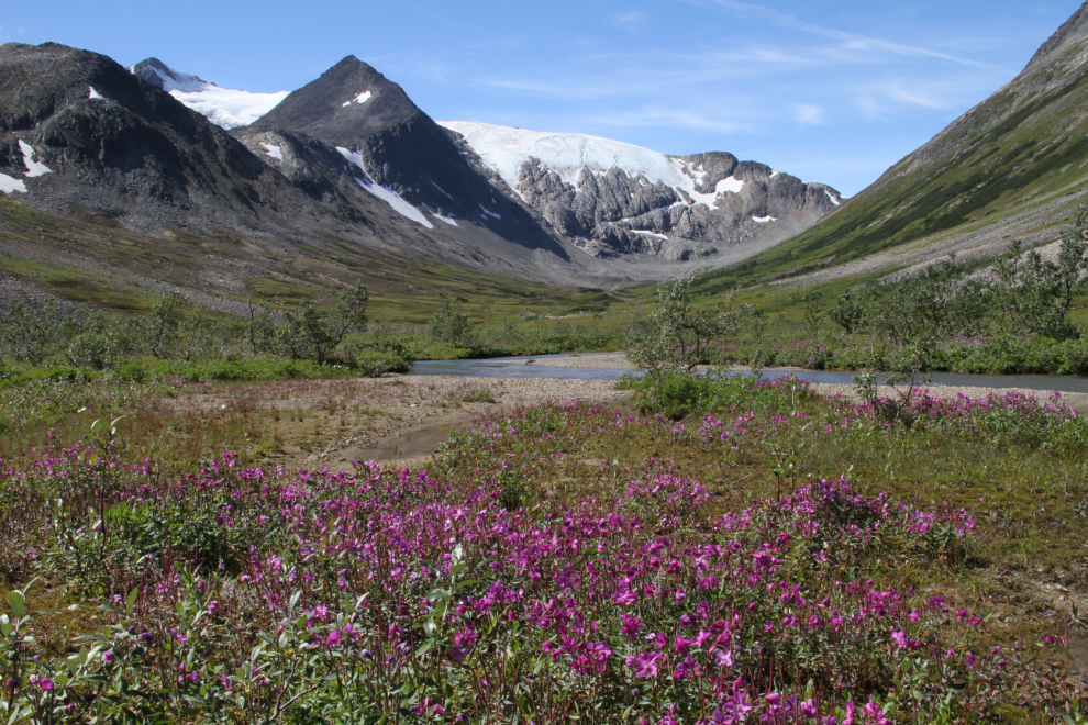
This image from Google Earth shows you the location of the glacier in relation to Bryant Lake and the Chilkoot Trail. Click here to open an interactive map in a new window.

Walking up the valley was tougher than it looked like it would be, with lots of water and marshy areas as wel as lots of tough brush. But it was so beautiful that none of us minded. Arctic cotton (Eriophorum callitrix) livened up some wet spots.

For those of us with water shoes of whatever kind, the creek provided the easiest walking in a few places.

Even this grass in shallow water was enough to stop me for a few photos.

At least six terminal moraines were visible as we walked toward the glacier. It’s been an incredible active glacier over the past few thousand years, advancing, retreating, and advancing again over and over.

The creek cutting through the third and largest of the terminal moraines.
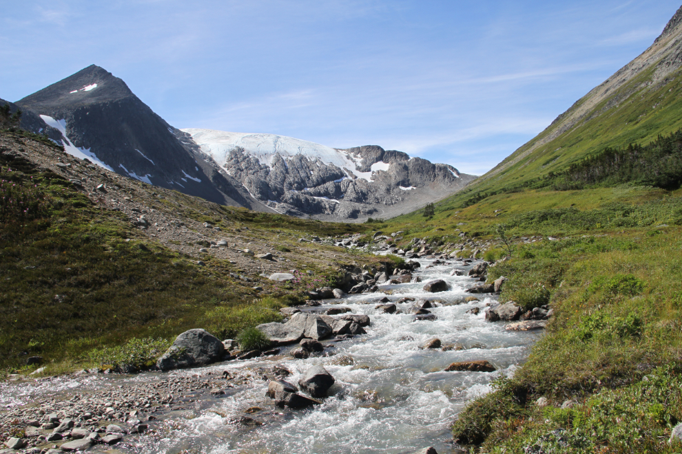
Three more small terminal moraines are visible in this photo. This is where most of us stopped.

The view back down the valley to Bryant Lake.

I need to dig out my photos from 20+ years ago – my memory is that the ice was down almost to the bottom of the bare solid rock.

Just before 3:30 pm, we started back, making a quick stop at the beach to pick up the gear we’d left there. The light was lovely for the walk back along the lake.

The fog had cleared out of the lower valley by the time we could see it again.

One final shot, taken at 5:45 pm. We reached the highway at 6:15, and a few minutes later were back at camp.

The plan for Sunday was to hike along the Canada/USA border from the highway to the railway – if the weather cooperated.