An epic BC road trip
BC has endless opportunities for epic road trips of any length you choose, with virtually any combination of scenery you could want, from desert to rainforest. I spend a lot of time planning major road trips, some of which happen and some of which don’t. Although I’m still planning the ultimate BC road trip, in September and October, I spent 30 days touring much of the province from my home base in Whitehorse, putting 6,562 kilometers (4,022 miles) on my motorhome plus a few hundred more on the small 4×4 I was towing. It would have been easy to spend far more time on this route, but while it was a fairly quick look at a lot of country, it was extremely rewarding. Some of the highlights of the trip, as well as other options in those areas, follow.
Click here to open an interactive map of the basic route in a new window.
Dawson Creek
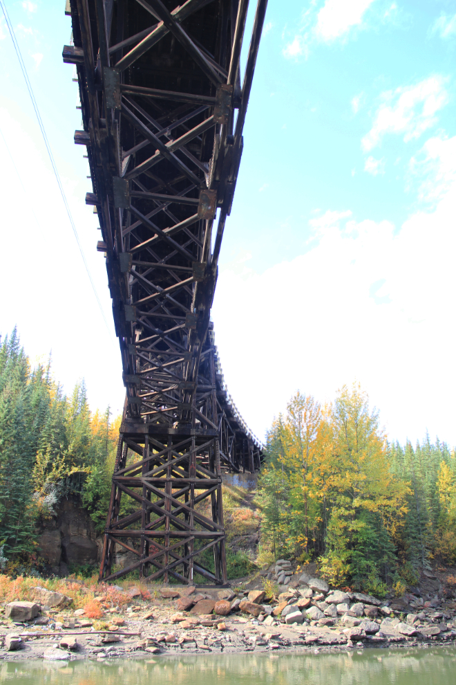
I visit Dawson Creek fairly regularly, and never tire of the wide range of attractions in the area. During the last visit, I went to the historic curved wooden Kiskatinaw Bridge (seen in the photo below), the Bear Mountain Wind Park, the very impressive abandoned railway trestle at Pouce Coupe, and McQueen Slough, a wetlands conservation and education site. The wonderful art gallery is a regular stop for me, but it’s closed until December for a major renovation. A visit to Alaska Highway House, as well as both “Mile 0” locations, is a good start to a drive up the highway, and the Railway Station Museum and Walter Wright Pioneer Village provide good looks at the area’s past.
Historic Kiskatinaw Bridge on an old section of the Alaska Highway
Hudson’s Hope
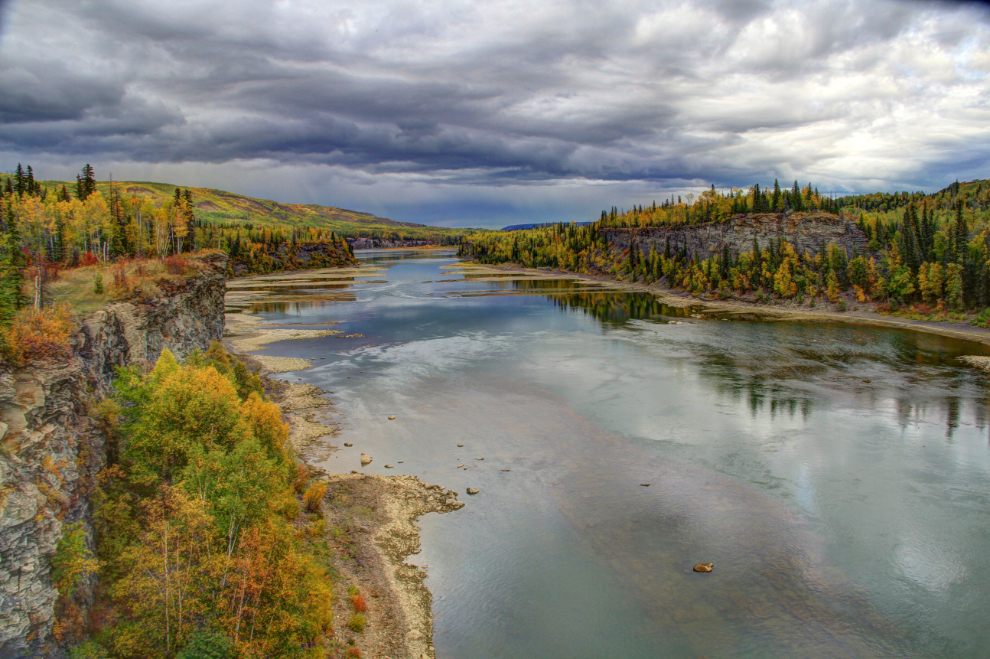
I had two main reasons to return to Hudson’s Hope on this trip, though I discovered more by doing some exploring. First, Highway 29 offers some superb views of the Peace River, including the one in the photo below. I also wanted to have another look at the W. A. C. Bennett Dam. Although I was too late, if you visit between Victoria Day and Labour Day, there’s a new visitor centre at the dam that is sure to greatly enhance that experience. The Peace Canyon Dam, a much smaller structure, is also worth a visit, and a short trail from the Alwin Holland Campground south of town takes you down to a section of the Peace River with dramatic layered and eroded rock formations.
Peace River near Hudson’s Hope
Jasper
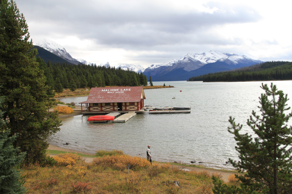
My next major stop was Jasper. It would take a book to describe all the activities available in the area, but on this trip I wanted to see some places that I either had never been to before, or hadn’t visited in decades. Mount Edith Cavell Road was first on that list. The 14-km-long road (8.7 mi) is narrow, twisting and steep, with Mount Edith Cavell, 3,363 meters high (11,033 feet) at the end of the road, from where several hiking trails can get you even closer. Moving inside, the Jasper-Yellowhead Museum & Archives was next. It’s an extremely good little museum, with excellent displays. The final destination before driving south on the spectacular Icefields Parkway was Maligne Lake, and even on a rather stormy day, the 34 kilometer (21 mile) drive off the highway was wonderful, past some truly stunning mountains that are very different than any seen along the highway.
Maligne Lake, Jasper, Alberta
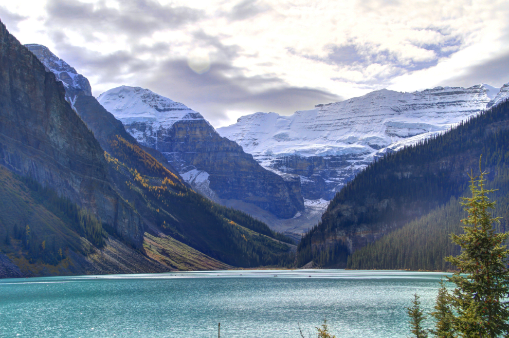
Lake Louise, Alberta
The view of Lake Louise below has been one of the iconic views in the Canadian Rockies since the first hotel was built at that location in 1890. At an elevation of 1,750 meters (5,740 feet), winter comes early to the lake and the lower townsite, but hiking and canoeing as well as other mountain-oriented sports can be enjoyed well into October.
Lake Louise
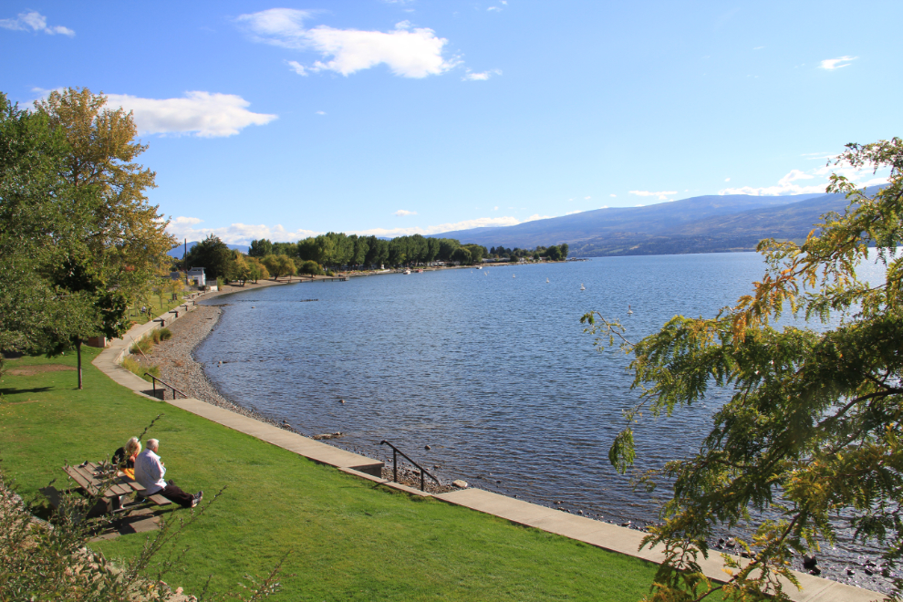
West Kelowna
West Kelowna was a good base for several days of exploring a bit of what the Okanagan Valley offers, from wine and cider tours to excellent dining, from marina strolls and hiking to just enjoying off-season-quiet beaches. The historic Myra Canyon railway trestles are a favourite place to walk or cycle, and the Kettle Valley Steam Railway in Summerland is another excellent stop for train or history buffs.
Gellatly Beach, West Kelowna
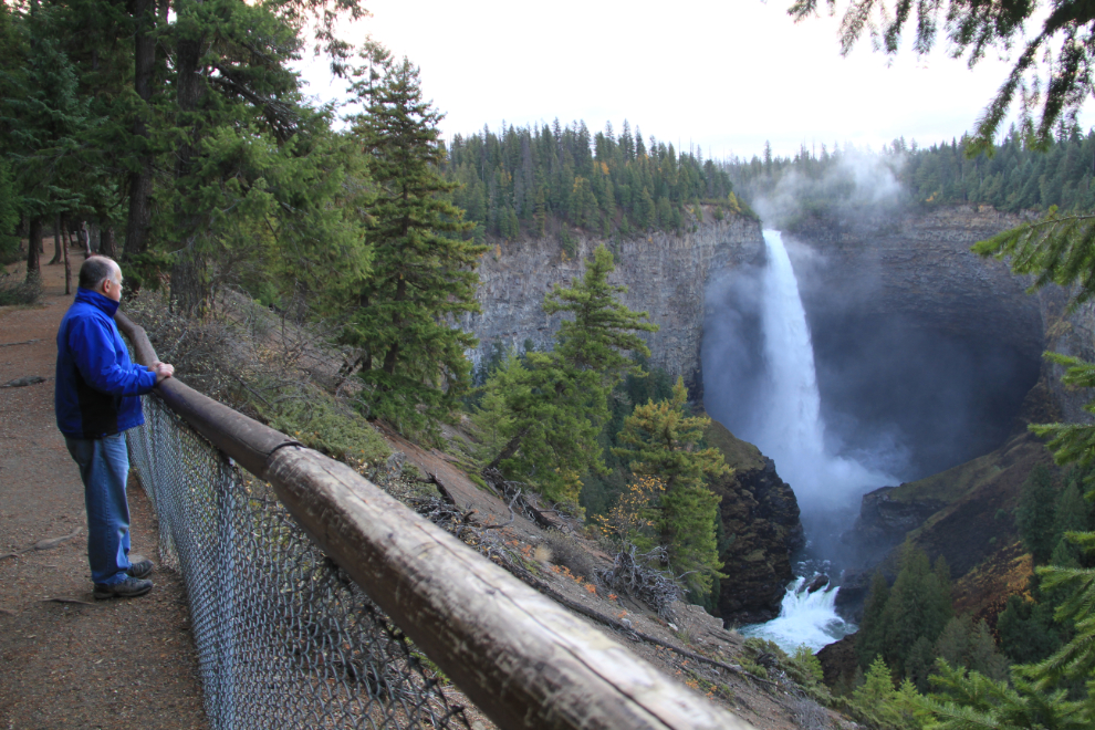
Wells Gray Provincial Park
A last-minute decision to make the fairly long detour into Wells Gray Provincial Park resulted in one of the most memorable 24 hours of the trip. Established on November 28, 1939, the 541,516 hectare (1,338,115 acre) park offers superb opportunities to see spectacular canyons and waterfalls as well as wilderness canoeing/boating, hiking and horseback trips. Only a small portion of the park, which has 39 named waterfalls, can be accessed by road. For many, Helmcken Falls is the primary reason to visit the park. At 141 meters (462 feet), it is the highest waterfall in the park and the fourth highest in Canada, but Spahats Falls, 73 meters (240 feet) high, and Dawson Falls are also wonderful and easy to access. For the more energetic, there are countless backroads and hiking trails to explore.
The author starting the day at Helmcken Falls
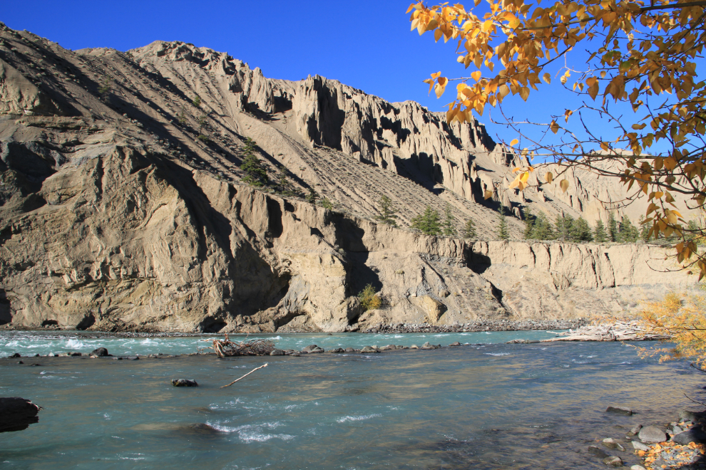
Williams Lake
The diversity of terrain around Williams Lake surprises most people. Within a very short distance you can go from rolling cattle ranching country to a dramatic canyon to forested mountains. Experiencing some of that natural diversity was my focus, and the Chilcotin River’s Farwell Canyon (seen below), Junction Sheep Range Provincial Park (home to approximately 500 California bighorn sheep), and the small Doc English Bluff Ecological Reserve provided an excellent look at the possibilities for future visits.
Farwell Canyon on the Chilcotin River
Fort St. James
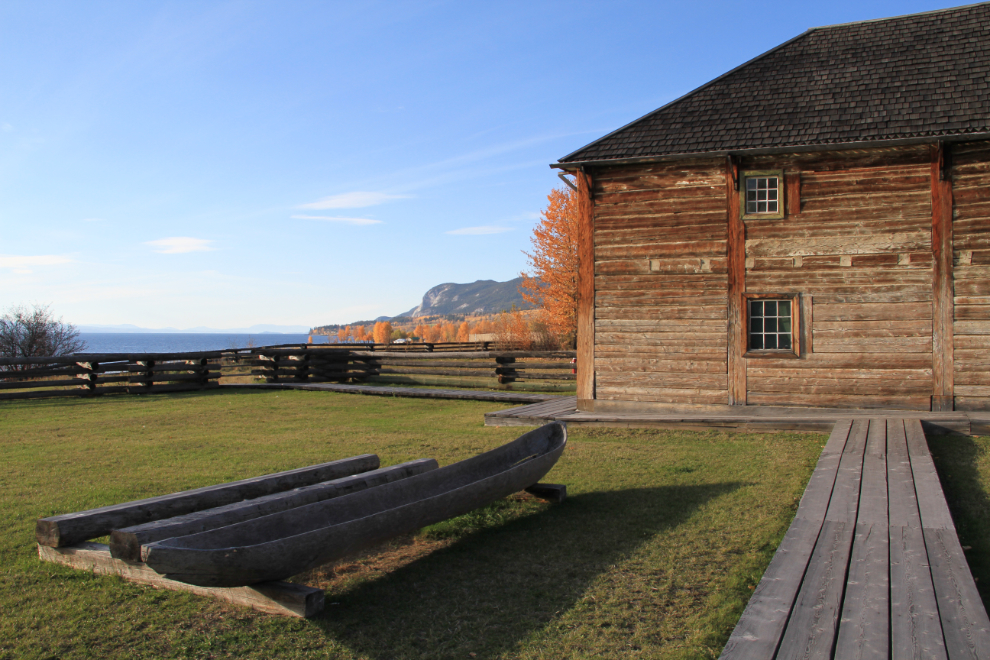
The main reason for my detour to Fort St. James was to see the fur trading fort, but I quickly discovered that there is much more to see. The setting of the fort – of the community as a whole – is beautiful, on the shore of Stuart Lake, which is 66 km (41 mi) long and 10 km (6.2 mi) wide. The fort, originally established by Simon Fraser for the North West Company in 1806, now provides an excellent look at life there in 1896, the target date for the restoration. A brochure for the Ripples of the Past Interpretive Trail led me next through the community and along the lake to several sites of importance, including the beautiful Our Lady of Good Hope Church which was built in 1873, and a memorial to pioneer bush pilot Russ Baker, whose first airline in Fort St. James eventually became Pacific Western Airlines. Beyond the exciting history, the area has some wonderful mountain and waterfall hiking trails, and boating of all types.
Fort St. James National Historic Site
Stewart
When it comes to a combination of scenery and mining history, Stewart is in a class of its own, hinted at by the dramatic approach to the community through Bear Pass and past the roadside Bear Glacier. Fans of frontier architecture will find plenty of buildings of interest, and the estuary boardwalk offers a unique look at that ecosystem at the edge of downtown. The tiny neighbouring community of Hyder, Alaska, promotes itself as the friendliest ghost town in Alaska, and beyond it, a large viewing deck offers exceptional bear viewing when the salmon are running from mid-July through early September. Keep going up that road, and you reach the Salmon Glacier, fifth largest glacier in Canada. A copy of the “Glacier Highway and Salmon Glacier Self Guided Auto Tour” brochure might encourage you to stay much longer than you originally expected to.
Salmon Glacier
